On this page (Sacred Geometry Design Sourcebook – sample – (page 224) Star Tetrahedron Fold-up Pattern), I made a table with a handful of map locations (latitudes and longitudes) that seem to (mostly) have volcanic features; I recently made a google map for a web client as a demo and then made another map of some fun places we visited in New Zealand a couple of decades ago. So now I’ve made a map of these “volcanic points” that correspond to points where a tetrahedron (actually a star tetrahedron)* would intersect the sphere of the earth. (No I didn’t calculate the minor latitude change that would account for the fact that the earth is actually a spheroid – slightly flattened at the poles, but these latitudes should be fairly close.)
* If one places one vertex of a tetrahedron on the north pole, the other 3 vertices would all be at about 19.5° South Latitude; If one places one vertex of a tetrahedron on the south pole, the other 3 vertices would all be at about 19.5° North Latitude, which you can see in the map below; the longitude points vary.
If I recall correctly when we were on the big island of Hawai’i years ago, a park ranger explained that the active volcanic activity over millennia has made the entire Hawaiian Island archipelago, but the location of the active lava formation remains at the same latitude. This would seem to confirm the fixed latitude of these “fire points” as Plato might describe them.
Speaking of maps, here’s a recent interesting NYT article about the ever-popular attempts to try to convey 3D in 2D and minimize the distortions inherent in that attempt: Can This New Map Fix Our Distorted Views of the World? I’m glad I noticed this link in the article to an interesting archive article about Buckminster “Bucky” Fuller’s Dymaxion map of the earth. If you want to try living in a geodesic, visit colleague Asha’s Pacific Domes website.
Of course, higher and higher frequency flattened geodesic nets (a.k.a. fold-up patterns) give less and less distortion, but at some point, we might well ask ourselves, why lose perspective by going to fewer dimensions and less complete and inclusive information? Our tiny view of the world is necessarily hopelessly infinitesimal, but our Inner Vision can transcend the apparent limitations of space, time, and specifics. :-)
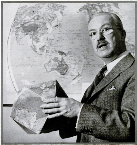
Here’s a photo of Bucky Fuller holding a cuboctahedron – an earlier map concept; the icosahedron having more faces works better. Here is what Wikipedia says about the Cuboctahedron: “Fuller applied the name “Dymaxion” to this shape, used in an early version of the Dymaxion map. He also called it the “Vector Equilibrium” because of its radial equilateral symmetry (its center-to-vertex radius equals its edge length)”
